


|
| |
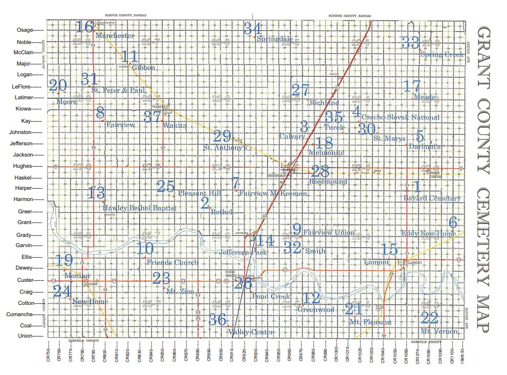
Map courtesy of Grant County Clerks Office
Cindy Pratt, Court Clerk
Jenna Kilian, Land Clerk
Hello, I am Nyree Coffman, area coordinator for Grant County, Oklahoma.
Okcemeteries is staffed entirely by volunteers. We receive no pay. Our goal is to get every headstone in every cemetery in Oklahoma online along with other related information. This is an effort to preserve the headstones as well as to help others in their research.
If you have information on cemeteries, obituaries, funeral home records, or photos that you would like to add here please email the area coordinator . Or if you can/would do look ups of any kind we would all be most grateful. Please be sure the county name and cemetery name are in the subject box in your email.
Help make this one of the most informative sites on the internet.
To submit an obituary or to volunteer to take tombstone photos at a cemetery, please email: area coordinator
As with all research, this is a source of information. It is up to the researcher to verify the data. The transcriber has attempted to transcribe the information as accurately as possible. This data may contain errors. Any additions or corrections greatly appreciated.
| Arbor Cemetery, aka Fairview Cemetery, aka Sand Creek Cemetery | On Line - This Site Complete Survey as of December 2011 Photographs have been taken and posted of the tombstones at this cemetery and have been posted. For further information, please e-mail: Area Coordinator |
This cemetery is located 4 miles north of State Highway 11 on State Highway 132, then 1 mile east on Kay Road; the cemetery fronts directly north on this dirt road. |
| Bayard Cemetery, aka Reynolds Cemetery, aka Deer Creek Cemetery | On Line - This Site Complete Survey as of February 2012 Photographs have been taken and posted of the tombstones at this cemetery. For further information, please e-mail: Area Coordinator |
This cemetery is located 1 mile west of Deer Creek on State Highway 11, then 2.5 miles south on County Road 1070 /or/ 5 miles north of the intersection of State Highways 60 and 74 on State Highway 74, then 1 mile east on Harmon Road, then .5 miles north on County Road 1070; cemetery fronts on the west side of this dirt road. |
| Bethel Cemetery, aka Klondike Cemetery | On Line - This Site Complete Survey as of December 2011 Photographs have been taken and posted of the tombstones at this cemetery. For additional information please e-mail: Area Coordinator |
This cemetery is located 9 miles east of the intersection of State Highways 132 and 11 on State Highway 132, then south for 4 miles on County Road 880, Trenton Road /or/ 6 miles north of the intersection of State Highways 81, 60 and 64, on County Road 880, Trenton Road, then east 1 mile on Greer Road, then north .5 miles on County Road 890 (not maintained; through wheat fields); cemetery is immediately east. |
| Czecho-Slovak Cemetery | On Line - This Site Complete Survey as of February 2012 Photographs have been taken and posted of the tombstones at this cemetery. For further information, please e-mail: Area Coordinator |
This cemetery is located 4 miles north of the intersection of State Highways 11 and 81 in Medford on State Highway 81, then 3.5 miles east on Kay Road; cemetery fronts on the north side of this dirt road. |
| Darland's Farm Cemetery | A photograph has been taken and posted of the single tombstone at this cemetery. For further information, please e-mail: Area Coordinator |
This cemetery is located 2 miles west of Deer Creek on State Highway 11, then 2 miles north on County Road 1060 to Jefferson Road; cemetery is located on the northwest corner of the intersection of County Road 1060 and Jefferson Road; the single stone in this cemetery is in the northwest corner of the property, under the largest tree in the area. |
| Dunkard Cemetery, aka Monitor Cemetery, aka Cupp Cemetery | On Line - This Site Complete Survey as of December 2011 Photographs have been taken and posted of the tombstones at this cemetery and have been posted. For further information please e-mail: Area Coordinator |
This cemetery is located 1 mile north of Nash on State Highway 132, and 1.5 miles west on Harmon Road; cemetery borders on the dirt road directly south. |
| Eddy New Home Cemetery | On Line - This Site Complete Survey as of February 2012 Photographs have been taken and posted of the tombstones at this cemetery. For further information, please e-mail: Area Coordinator |
This cemetery is located 4 miles east of the intersection of State Highways 60 and 74 outside Lamont, then 2.5 miles north on County Road 1100; cemetery fronts on the west side of this dirt road. |
| Fairview Cemetery, aka McKeeman Cemetery | On Line - This Site Complete Survey as of December 2011 Photographs have been taken and posted of the tombstones at this cemetery. For further information, please e-mail: Area Coordinator |
This cemetery is located 6 miles east of the intersection of State Routes 11 and 11A, which is 5 miles west of Medford on State Route 11, then south on County Road 910 for 2 miles, then east on Harper Road .25 miles; cemetery borders directly south of this dirt road. |
| Friends Church Cemetery, aka Coldwater Cemetery, aka Kent Cemetery | On Line - This Site Complete Survey as of December 2011 Photographs have been taken and posted of the tombstones at this cemetery. For additional information, please e-mail: Area Coordinator |
This cemetery is located 5 miles east of Nash on State Highway 64, which is 5 miles west of the intersection of State Highways 60, 64 and 81, then north 2 miles on Trenton Road, aka County Road 830, then east on Ellis Road .5 miles; cemetery is north of the dirt road about 50 yards. |
| Gibbon Cemetery | On Line - This Site Complete Survey as of December 2011 Photographs have been taken and posted of the tombstones at this cemetery. For further information, please e-mail: Area Coordinator |
This cemetery is located 9 miles north of the intersection of State Routes 132 and 11, on State Route 132, to east on Major for 3.4 miles; then, turn north across about 40 yards of wheat field into the original farmstead. Follow the trail around the outside of the pasture fence behind the farmstead where it turns north toward a couple of lone cedar trees which are the landmarks of the cemetery. |
| Greenwood Cemetery, aka Goldsmith Cemetery | On Line - This Site Complete Survey as of December 2011 Photographs have been taken and posted of the tombstones at this cemetery. For further information please e-mail: Area Coordinator |
This cemetery is located from Pond Creek, south on County Road 920 for 2 miles, then east on Cotton Road for 5.5 miles; cemetery is immediately south of this dirt road. |
| Grant County Cemeteries List |
On Line - this site | Submitted by: Tammie Chada |
| Grant County Funeral Homes |
On line - this site | Submitted by: Gene Phillips and Tammie Chada |
| Hawley Cemetery, aka Bethel Baptist Church Cemetery | On Line - This Site Complete Survey as of December 2011 Photographs have been taken and posted of the tombstones at this cemetery. For additional information, contact: Area Coordinator |
This Cemetery is located 8 miles north of Nash on State Highway 132, or 3 miles south of State Highway 11, then east .75 miles on Harmon Road; cemetery is directly south of the gravel road |
| Lamont Cemetery | On Line - This Site Complete Survey as of December 2011 Photographs have been taken and posted of the tombstones at this cemetery. If you would like to add any information, please e-mail: Area Coordinator |
This cemetery is located 4 miles east of the intersection of State Highways 60 and 74, called Main Street through Lamont, then north on State Highway 74 east of Lamont when it turns off for about 100 yards, then back west on Ellis Road for 1.5 miles; the cemetery fronts directly north of this paved road. |
| Liberty Cemetery, aka Fairview Union Cemetery, aka German Cemetery | OnLine - This Site Complete Survey as of February 2012 Photographs have been taken and posted of the tombstones at this cemetery. For further information, please e-mail: Area Coordinator |
This cemetery is located 4 miles north of the junction of State Highways 60 and 81 in Pond Creek on State Highway 81, then 4.5 miles east on Grady Road; the cemetery fronts on the south side of this dirt raod. |
| Manchester Cemetery | On Line - This Site Complete Survey as of October 2011 Photographs have been taken and posted of the tombstones at this cemetery, and have been posted. For further information, contact: Area Coordinator |
This cemetery is located 1 mile south of the Kansas-Oklahoma Border, 1/2 mile south of Manchester, /or/ 12.5 miles north of State Highway 11, at the corner of State Highway 132 and Osage Road; the cemetery fronts onto Osage Road, immediately to the south. |
| Meade Cemetery, aka Williams Cemetery, aka Cowal Farm Cemetery | On Line - This Site Complete Survey as of March 2012 Photographs have been taken and posted of the 2 tombstones at this cemetery. For further information, please e-mail: Area Coordinator |
This cemetery is located 1 mile west of Deer Creek on State Highway 11, then 6 miles north on County Road 1070, then .5 miles west on Latimer Road; cemetery sits on the north side of this dirt road. A single cable on metal poles surrounds this small area. |
| Mennonite Church Cemetery, aka Sunbeam Cemetery | On Line - This Site Complete Survey as of February 2012 Photographs have been taken and posted of the tombstones at this cemetery. For more information, please e-mail: Area Coordinator |
This cemetery is located 2 miles north of the intersection of State Highways 11 and 81 in Medford, on State Highway 81; then 1 mile east on Jefferson Road; cemetery is on the northwest corner of the intersection of County Road 980 and Jefferson Road. |
| Moore Family Cemetery. | On Line - This Site Complete Survey as of January 2012. Photographs have been taken and posted of the tombstones at this cemetery. For further information, please e-mail: Area Coordinator |
This cemetery is located 3 miles west of the intersection of State Highways 132 and 11 on State Highway 132, then north for 3.5 miles on County Road 760; cemetery is about 10 yards west of this dirt road. |
| Mount Zion Cemetery | On Line - This Site Complete Survey as of December 2011 Photographs have been taken and posted of the tombstones at this cemetery. For further information, please e-mail: Area Coordinator |
This cemetery is located 3 miles west of the interesction of State Highways 60, 64 and 81, which is 7 miles East of Nash on State Highway 64, then .5 miles south on County Road 850; cemetery borders directly east of the dirt road. |
| Mt. Pleasant Cemetery | On Line - this site Complete Survey as of February 2012 Photographs have been taken and posted of the tombstones at this cemetery. For further information, please e-mail: Area Coordinator |
This cemetery is located 4 miles south of the interesection of U. S. Highway 60 and State Highway 74 on State Highway 74, then west on Comanche Road for 2.5 miles; cemetery fronts on the immediate south of this dirt road. |
| Mt. Vernon Cemetery | On Line - This Site Complete Survey as of December 2011 Photographs have been taken and posted of the tombstones at this cemetery. For further information, please e-mail: Area Coordinator |
This cemetery is located 5 miles south of the intersection of U. S. Highway 60 and State Highway 74 on State Highway 74, then east on Coal Road for 4 miles; cemetery opens on the north side of this dirt road, at the intersection of Coal Road and County Road 1080. |
| New Home Cemetery | On Line - This Site Complete Survey as of February 2012 Photographss have been taken and posted of the tombstones at this cemetery. For further information, contact: Area Coordinator |
Cemetery is located two miles west and 1.5 miles south of Nash, on County Road 2770. Directions supplied by: Dave & Grace Erickson |
| Pleasant Hill Cemetery, aka James Cemetery, aka Harmon Cemetery | On Line - This Site Complete Survey as of December 2011 Photographs have been taken and posted of the tombstones at this cemetery. For further information, contact: Area Coordinator |
Cemetery is located 2 miles south of the intersection of State Highways 11 and 11A, on 11A, then 1 mile east on Harper Road, then 1 mile south on County Road 860 for .5 miles; cemetery is east of this dirt road about 100 yards. |
| Pond Creek Cemetery | On Line - This Site Complete Survey as of April 2012 Photographs have been taken and posted of the tombstones at this cemetery. For further information, please e-mail: Area Coordinator |
Cemetery is located .75 miles east of the junction of U. S. Highways 60, 64 and 81 which becomes Broadway in the town of Pond Creek, then south on Judith Jane Ln, aka S. Cherokee, which becomes County Road 920.5, for 1.25 miles. |
| Richland Cemetery | On Line - This Site Complete Survey as of February 2012 Photographs have been taken and posted of the tombstones at this cemetery. For further information, please e-mail:Area Coordinator |
Cemetery is located 6 miles north of the intersection of State Highways 81 and 11 in Medford, then 2.75 west on Latimer Road; cemetery fronts on the south side of this dirt road. |
| Rosemound Cemetery, aka Medford Cemetery | On Line - This Site Complete Survey as of December 2011 Photographs have been taken and posted of the tombstones at this cemetery and have been posted by: Area Coordinator |
This cemetery is located 1.5 miles east of Medford on State Highway 11, on the south side of the highway .25 miles along the cedar-lined entry. |
| Saint Josephs Cemetery | For further information, please e-mail: Area Coordinator | Section E of Pond Creek cemetery is the Catholic section. It was conveyed to the Catholic Church (St Joseph's) in 1897 and early obituaries refer to that section as St Joseph's cemetery. The Catholic Church conveyed Section E back to Pond Creek cemetery 25 years later in 1923. It has been referred to as the Catholic section since that time. This is per the Silent Cities book for Grant County and is information from the current Cemetery Association. |
| Saint Peter and Saint Paul Cemetery | On Line - This Site Complete Survey as of December 2011 Photographs have been taken and posted of the tombstones at this cemetery. For additional information please e-mail: Area Coordinator |
Cemetery is located 7 miles north of the intersection of State Highways 132 and 11 on State Highway 132, then .25 miles west on LeFlore; cemetery is immediately north of this dirt road. |
| Smith Cemetery | On Line - This Site Complete Survey as of February 2012 Photographs have been taken and posted of the tombstones at this cemetery. For further information, please e-mail: Area Coordinator |
This cemetery is located 4 miles north of the intersection of State Highways 60 and 81 in Pond Creek on State Highway 81, then 4.6 miles east on Grady Road to 1 mile south on County Road 970; cemetery in on the southeast corner of the intersection of County Road 970 and Garvin Road hidden in a grove of trees. |
| Spring Creek Cemetery, aka Troxel Cemetery | On Line - This Site Complete Survey as of March 2012 Photographs have been taken and posted of the tombstones at this cemetery. For more information, please e-mail: Area Coordinator |
This cemetery is located 1 mile west of Deer Creek on State Highway 11, then 10.25 miles north on County Road 1070; cemetery opens on the east side of this dirt road. |
| Springdale Cemetery, aka Lyle Cemetery | On Line - This Site Complete Survey as of March 2012 Photographs have been taken and posted of the tombstones at this cemetery. For further information, please e-mail: Area Coordinator |
This cemetery is located 4 miles west of Medford on State Highway 11, then 11.5 miles north on County Road 920; cemetery opens on the west side of this dirt road. |
| St. Anthony's Cemetery, aka Clyde Cemetery | On Line - This Site Complete Survey as of February 2012 Photographs have been taken and posted of the tombstones at this cemetery. For further information, please e-mail: Area Coordinator |
This cemetery is located 5 miles west of Medford on State Route 11, then north on County Road 910 for 2.25 miles; cemetery is situated about 150 yards to the east of this paved road. |
| St. Mary Calvary
Cemetery aka New St. Marys Cemetery, aka St. Marys Catholic Cemetery |
On Line - This Site Complte Survey as of March 2012 Photographs have been taken and posted of the tombstones at this cemetery. For more information, please e-mail: Area Coordinator |
This cemetery is located 2.5 miles north of the intersection of State Highways 11 and 81 in Medford, on State Highway 81; cemetery opens on the west side of this Highway. |
| St. Marys
Cemetery aka Old St. Marys Cemetery |
On Line - This Site Complete Survey as of February 2012 Photographs have been taken and posted of the tombstones at this cemetery. For further information, please e-mail: Area Coordinator |
This cemetery is located 7 miles east of the intersection of State Highways 11 and 81, on State Highway 11, then 3 miles north on County Road 1030, then .5 miles east on Johnston Road; cemetery opens on the north side of this dirt road. |
| Turek Cemetery, aka Skrdla Cemetery, aka Bauer Cemetery, aka Dick Cemetery | Photographs have been taken and posted of the 3 tombstones at this cemetery. For further information, please email: Area Coordinator |
This cemetery is located 3 miles north of the intersection of State Highways 11 and 81 in Medford, on State Highway 81, then 3 miles east on Johnston Road; cemetery opens on the north side of this dirt road. |
| Valley Center Cemetery | On Line - This Site Complete Survey as of February 2012 Photographs have been taken and posted of the tombstones at this cemetery. For further information please e-mail: Area Coordinator |
This cemetery is located 3 miles south of the interesection of U. S. Highways 81, 64, and 60, then east 3 miles on Comanche, then south another mile on County Road 900, then east again on Coal Road for .5 miles /or/ from Pond Creek, south on County Road 920 for 4 miles, then west on Coal Road for 1.5 miles; cemetery is immediately north of this dirt road. |
| Wakita Cemetery | On Line - This Site Complete Sruvey as of November 2011 Photographs have been taken and posted of the tombstones at this cemetery. For further information, please e-mail: Area Coordinator |
This cemetery is located 4 miles north of State Highway 11 on State Highway 11A /or/ .5 miles west of Wakita on Wakita Road then 1 mile south on State Highway 11A. Cemetery is directly west of this paved highway. |
This site may be freely linked, but not duplicated in any way without consent.
All rights reserved! Commercial use of material within this site is prohibited!
© 2000-2026 Oklahoma CemeteriesThe information on this site is provided free for the purpose of researching your genealogy. This material may be freely used by non-commercial entities, for your own research, as long as this message remains on all copied material. The information contained in this site may not be copied to any other site without written "snail-mail" permission. If you wish to have a copy of a donor's material, you must have their permission. All information found on these pages is under copyright of Oklahoma Cemeteries. This is to protect any and all information donated. The original submitter or source of the information will retain their copyright. Unless otherwise stated, any donated material is given to Oklahoma Cemeteries to make it available online. This material will always be available at no cost, it will always remain free to the researcher.