 |
 |  |
This information is available for free. If you paid money for a
subscription to get to this site, demand a refund.
For any questions pertaining to an individual cemetery, you would need to contact the cemetery sexton / board / caretaker.
|
| |
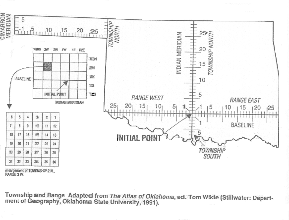
Township and Range
The distictive checkerboard pattern of land boundaries in the West was conceived by Thomas Jefferson in the early 1780's--long before the rough and rugged character of this vast wilderness had been charted.Ā Although Jefferson himself never ventured much farther west than the Appalachians, his plan for surveying and subdividing public land west of the Ohio River left a permanent imprint on all the western states.Ā Jefferson, the gentleman farmer of Virginia who imagined the West to be a mirror image of the East, was the grand architect of the western landscape.
Jefferson's plan, set down in the Land Ordinance of 1785, reflected the rational spirit of the time and not the implications of natural topography.Ā Discarding the traditional surveying concept of "metes and bounds" (which took natural features of the land into account), he designed a strict grid system.Ā First an east-west base line was drawn; this so-called Geographer's Line started where the Ohio River intersected the Pennsylvania boundary and extended due west.ĀEvery six miles at right angles to the Geographer's Line, meridians were drawn, progressively numbered from east to west, beginning with the number 1.Ā Intersecting the meridians, at 6 mile intervals, lateral lines were drawn and numbered from south to north, likewise beginning with the number 1.Ā Each resulting square formed the boundaries of a 36 square mile tract called a township.Ā A township was further subdivided into 36 sections of one square mile each, or 640 acres.Ā In each township, section 16 was reserved for public education.Ā The township was the basic unit of land surveys in the West and is still the standard, with only a few exceptions.
The first survey based on the 1785 ordinance was know as the Survey of the Seven Ranges and took place in 1785-1786, surpervised by government geographer Thomas Hutchins.Ā After Jefferson was elected president, he initiated the famed Lewis and Clark expedition, the first transcontinental exploration in U. S. history.Ā The expedition, which lasted from 1804 to 1806, returned with the first detailed maps of the western region.Exploration of the West culminated in the surveys of Ferdinand V. Hayden, head of the Geological and Geographical Survey of the Territories.Ā Hayden and his "topographical engineers" often lugged 50-pound transits and other equipment to the tops of 14,000 foot peaks in order to make their triangulations.Ā Beginning in the 1850's and lasting well into the 1870's, Hayden's expeditions produced maps of such clarity and accuracy that they have endured as authoratative models of cartography.Ā In 1879 Hayden was instrumental in founding the U. S. Geological Survey, which consolidated federal surveying activities and began the national mapping program that continues today, based on Jefferson's concept.
One feature of Jefferson's original plan for the West was never adopted, however: he wanted the new states to be given such names as Dolypotamia, Assenisippia and Metropotamia.
Federal land surveys in Oklahoma began in 1870, when Ehud Darling, a professional surveyor of the West, established the initial reference point for the township and range grid for Indian Territory.Ā This point, which Darling marked with a pile of rocks at a spot about one mile south of Fort Arbuckle in present-day Murray County, is where a north-south line (called the Indian Meridian) and an east-west baseline intersect.Ā Any place north or south of the base line is designated as township north or township south, respectively.Ā Its position east or west of the Indian Meridian indicates its range (i.e. range east or range west).Ā Township and range numbers start with the number 1 at the initial point, so the four townships clustered around the intersection of the Indian Meridian and the base line are designated (clockwise) as follows: T1N R1E; T1S R1E; T1S R1W; T1N R1W.Ā The farther away a township is from the initial point in any direction, the larger the township and range numbers.Ā Section numbers, on the other hand, are numbered from north to south, starting in the northeasternmost corner.Ā The first, third and fifth rows are numbered from east to west , the second, fourth and sixth rows from west to east.Ā This numbering system is shown in the illustration above.Ā Excluding the Panhandle (where a separate initial point was used), all land in Oklahoma can be described by the same grid system.
Sources
Commager, Henry Steele, ed. Documents of American History. 2 vols.Ā Englewood Cliffs, N. J.: Prentice-Hall, 1973.
Concise Dictionary of American History. New York: Scribner's, 1983.
Oklahoma Almanac, 1995-1996.Ā Oklahoma City: Oklahoma Department of Libraries, 1995.
Raban, Jonathan. "The Next Last Frontier" Harper's, August 1993.
The Roads of Oklahoma, 1997. Shearer Publishing
This site may be freely linked, but not duplicated in any way without consent.
All rights reserved! Commercial use of material within this site is prohibited!
© 2000-2026 Oklahoma CemeteriesThe information on this site is provided free for the purpose of researching your genealogy. This material may be freely used by non-commercial entities, for your own research, as long as this message remains on all copied material. The information contained in this site may not be copied to any other site without written "snail-mail" permission. If you wish to have a copy of a donor's material, you must have their permission. All information found on these pages is under copyright of Oklahoma Cemeteries. This is to protect any and all information donated. The original submitter or source of the information will retain their copyright. Unless otherwise stated, any donated material is given to Oklahoma Cemeteries to make it available online. This material will always be available at no cost, it will always remain free to the researcher.