


|
| |
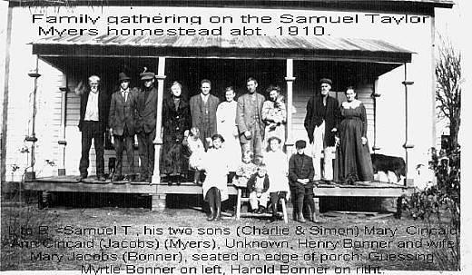 |
Oakwood cemetery was created when Samuel Taylor Myers, a single man, deeded a two acre plot to the Oakwood cemetery Association from the southeast corner of his homestead on September 24, 1892. Samuel Myers had claimed this homestead in the land run of 1889. The "Oakwood Cemetery Association" was given formal approval by the Oklahoma Territorial Secretary in a signed patent dated August 9, 1892. The "Edmond Sun" published that Samuel Taylor Myers died on June 30, 1935, and was numbered among the last survivors of the Civil War residing in Edmond.
An organizational meeting was called on September 26, 1892 and the handwritten bylaws began:
In order to prepare a permanent resting place for the dead, and to secure for the living perfect titles to the same, the undersigned residents of the Town of Lincoln {apparently the name then used by the unincorporated area near the cemetery} and adjoining Towns of Oklahoma County, Oklahoma Territory, agree to form an association and be governed by the following constitution.
Lots {containing six spaces} were initially priced at $5.00 and all officers served without pay except the Secretary who was to receive 15% of the amount of lots sales. Samuel T. Myers was elected President and Robert A. Lord was elected Secretary.
The cemetery was formally surveyed by H. H. Highsmith on December 16, 1892. In the survey it is stated that the dimensions of the cemetery are 300 feet from North to South and 264 feet from East to West (exactly 2 acres), not counting the section line easements. It is laid out in four blocks with crossing streets and a fifteen foot "passway" all around. The four blocks are numbered from the northeast corner {one}, northwest {two}, southwest {three}, and southeast {four} "in the same manner as sections in a township". Each lot is 24 feet by 12 feet containing six burial spaces {four feet by twelve feet} with a five foot walkway around each lot except where it abuts a street. The lots are numbered from the northeast corner of each block. Burial spaces are laid out East to West and are numbered from the North to the South {1-6}. Headstones traditionally are placed on the West End of the space with wording facing the West, so that you may read the memorial without standing on the grave.
The survey specifies that "Lots one through twenty in Block One are to be reserved for a colored peoples' "graveyard". This area was bounded on the South by a seventeen-foot street. This provision was changed by a unanimous vote of the association in 1951 when a non-segregation policy was adopted.
{Information obtained from OK County Cemetery Index - compiled by OK County HCE Genealogy Group, page 76.}
This site may be freely linked, but not duplicated in any way without consent.
All rights reserved! Commercial use of material within this site is prohibited!
© 2000-2026 Oklahoma CemeteriesThe information on this site is provided free for the purpose of researching your genealogy. This material may be freely used by non-commercial entities, for your own research, as long as this message remains on all copied material. The information contained in this site may not be copied to any other site without written "snail-mail" permission. If you wish to have a copy of a donor's material, you must have their permission. All information found on these pages is under copyright of Oklahoma Cemeteries. This is to protect any and all information donated. The original submitter or source of the information will retain their copyright. Unless otherwise stated, any donated material is given to Oklahoma Cemeteries to make it available online. This material will always be available at no cost, it will always remain free to the researcher.